The EUSATfinder fleet of drones
Fixed wings drone: Boreal with GEO MSS and Galileo OSNMA enabled GNSS Rx
The BOREAL drone system is composed of a less than 25Kg fixed wing with high endurance (1000km, 10h of flight) and with large payload carrying capacity (5Kg). Among the applications and due to its great endurance, the BOREAL system has demonstrated its relevancy for surveillance called ISR (Intelligence, Surveillance, Recovery) as well as for experimental applications thanks to its payload capacity, its robustness and its volume available for the payload.
In complement to rotary wings UAVs, fixed-wings drone will be used in EUSATfinder for long range flight/missions. In this respect, M3SB will bring to the project its long range fixed-wing drone, named BOREAL. It is a system that consists of a vector of type fixed-wing (4 m wingspan) with rear engine. This configuration gives it great stability in flight, associated with a significant payload capability (up to 5 kg) and flight duration of up to 10h.
The main interest on this solution is to ensure the surveillance on area size that cannot be covered by rotary wings solutions. In EUSATfinder project, two configurations of the BOREAL drone will be used. With the ISR (Intelligence, Surveillance, Recovery) drone equipped with a gimbal camera which permits to covers a scene with real-time transmission of HD video via the UHF link.
The First version will be equipped with a camera, onboard processing capacity and a SATCOM modem for images transmission via INMARSAT whereas in the second configuration an IRIDIUM service is used provided by TPZ. In addition, "pollicino" tracker box is used for integration to the U-Space service provider USSP in Italy via SATCOM communications.
The ISR configuration of the BOREAL, which is a COTS product, will be used for the project. It consists of a BOREAL vector equipped with a long-range VHF radio link for C2 and datalink (up to 80km), satcom link for C2 once beyond UHF reach. A day EO / night IR optronic turret is already installed in the ISR configuration. For the purpose of EUSATfinder, a GNSS record solution (Galileo enabled) will be installed as well, and the interface with the project infrastructure will be developed.
Rotary wings drones: ATMO(s) with LEO MSS and Galileo OSNMA enabled GNSS Rx
Atmosphere has developed two octocopter drones where the focus of operations has been and will subsequently be not the drone as future product, but particularly to use the platform for continuous optimization and verification of secure and performant on-board connectivity solutions for both, C2 and mission data. ATMO-1 and ATMO-2 drones are displayed in Figure ‑12. Due to the typical size, weight and flight duration limits of an electrical rotary-wing UAV, the on-board satcom terminal must be as small and light-weight as possible, and hence a LEO MSS solution has been chosen, more particularly a second-generation Iridium Certus terminal which is developed and manufactured by Atmosphere. Being an Iridium value-added manufacturer, ATM can bring airtime plans and further benefits of commercial satcom for R&D&I projects along inherently with the terminal.
The primary drone for the project will be the more powerful ATMO-2, which is in the max. 25kg category. The current standard payload consists of a 360° camera, a WiFi access point offering local connectivity to standard WiFi devices in the field, and a tailored 5G modem providing a backhaul link to a ground based 5G campus network. The satcom terminal may also be used for payload communications (besides its main task as the C2 BVLOS link), however with limited bit rate capabilities of 22/88 kbit/s up/down as the smallest Certus category. However not only relevant IoT and position data for typical first responder applications, but also still pictures or low-resolution compressed video can always be transmitted if there is no strict real-time requirement. A more recent upgrade with a highy efficient adaptive video streaming capability also allows real-time video with dynamic limitations in rate, resolution and field of concern. Reliable and secure C2 communication is provided over complementary links (UHF, 5G, satcom) and a specific version of enhanced MAVLINK protocol by ATM. For the EUSATfinder flights in Italy, the drone will also be equipped a Pollicino GNSS tracker to achieve national USSP compliance.
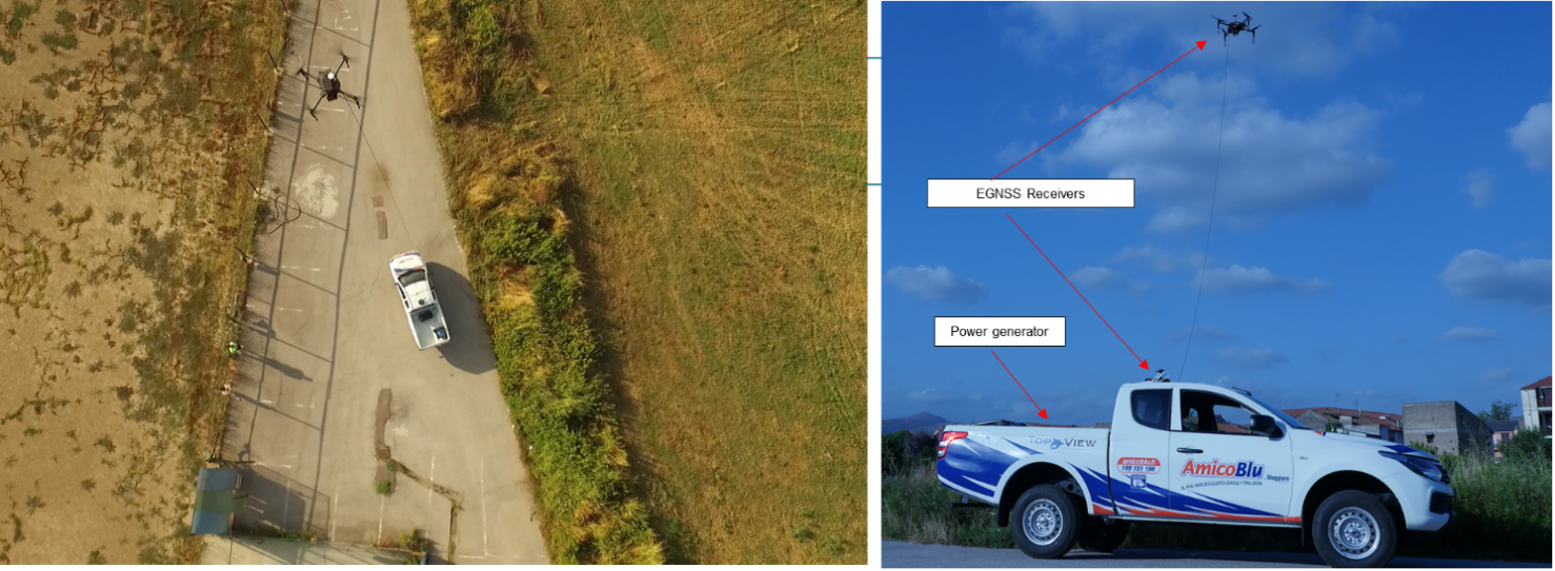
Tethered Rotary wings drone: TSP system with Galileo OSNMA enabled GNSS Rx
Nowadays tethered drones are used in a lot of domains to provide a consistent support for surveillance purposes.
In each of the application fields reported in the above figure, the following needs are identified:
-
CONTINUITY: Drones shall be able to fly for hours, allowing long endurance surveillance operations by day and night.
-
USABILITY: Drones shall be robust, quick to use and deploy, (even in a mobile platform as reported in figure) providing an effective solution for persistent aerial surveillance.
-
COVERAGE: Drones shall cover wide areas as many square kilometer in some cases and thus provide information for a complete situational awareness
-
SECURITY: Drones have to be intended as an additional segment of the overall surveillance infrastructure and as consequence has to be protected against accidental and intentional attacks.
Based on the abovementioned parameters, a so called “Tethered solution” is a very interesting candidate for first responders operations consisting in coupling a drone with a fixed point on the ground (a hangar) providing power:
-
Power over cable for extended flight time operations;
-
C2 link data security & integrity through cable for spoofing rejection
-
Physical constraint to limit the drone envelope of flight, easing authorization requests
Moreover, The Tethered drone will be used as a Communication relay, with the following main components
-
Hot Spot Station for Advanced Operative Center (COA) located with the MOC
-
Master Thetered Drone (MTD) (UAV1)
-
Hot Spot Station for Home Point (HSS
The bandwidth of the network will be adequate for real-time video streaming from the aerial drone and the underwater drone to the COA, simultaneously during the respective environmental monitoring operations.