Hazard management in a previously monitored area
In CPA (Civil Protection Authorities) practices, the need for intervention criteria based on quantified risk is rising and becoming decisive for implementing effective disaster risk reduction strategies. Geohazard management and mitigation practices involve the correct choice of the monitoring system (remotely sensed or in situ), the selection of the geohazards to be prioritized (in terms of allocated resources), and the development of a real-time or near-real-time monitoring service with ad hoc alerts based on thresholds. At a regional scale, it is crucial to have a solution enabling the CPA to investigate the largest possible extension of the territory and to detect new hazard phenomena or changes of the existing ones as early as possible. This screening capability provides the CPA with the opportunity to perform a full-scale regional assessment of the geohazards, with a proper allocation of human and financial resources. From an operational point of view, an efficient monitoring solution should be able to be deployed in all the different operational phases of disaster management: i) prevention and preparedness, ii) emergency and response, iii) recovery. EUSATfinder system shall provide a scalable, portable and usable solution in order to configure the proper architecture depending on the selected phases. Therefore, it is worth highlighting that a robust regional monitoring system integrated into the CPA cycle requires multi-source techniques to retrieve the most reliable and complete information possible. Moreover, effective communication among first responders during and in the aftermath of a disaster can affect outcomes dramatically. There is a concrete need to build a resilient architecture that allows first responders to communicate even with:
- damage to infrastructure – civilian and/or specialized communication facilities may be damaged by the disaster;
- congested channels – because affected people report something about the disaster, and these messages may be broadcast;
- dynamically formed groups – first responder teams may be formed dynamically in response to a disaster and team member addresses (e.g., phone numbers) may not be known to one another;
- impediments to communication – because the new command chain to manage the disaster may be different from the original organizational hierarchy;
- poor interoperability – each sub-team might use different communication facilities, and it could be different to have the possibility to communicate with the whole involved persons.
- security attacks – disaster situations are often vulnerable to attacks, requiring authentication and authorization as well as establishing data integrity and provenance;
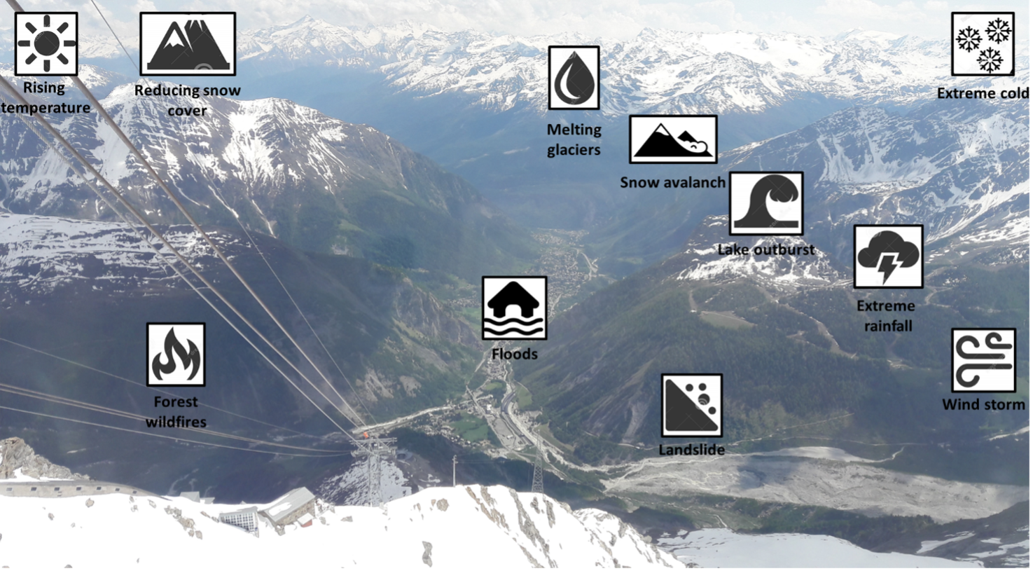
The Aosta Valley seen from Pointe Helbronner (Mont Blanc massif). The municipality of Courmayeur is seen with the valley floor. On the right the lower section of the Brenva Glacier, on the left the entrance of the Val Ferret. Valle d’Aosta climate-related hazards: crucial issues in the light of the accelerating global warming, because of which regions in the alpine settings are increasingly experiencing warm weather patterns.
The Planpincieux Glacier, a hanging glacier located on the southern slopes of the Grandes Jorasses in the Mont Blanc massif is a temperate glacier largely investigated in the last decade with optical cameras and meteo station to analyse the dynamics of ice collapses. The lower (terminal) part of the Planpincieux glacier is very active and characterized by the presence of crevasses and seracs, and collapse phenomena that make these areas difficult to access and very dangerous. The difficulty of access is high especially in the suspended glacier front. Over the years, several ice avalanches and glacial outburst floods have occurred that posed a threat to the hamlet of Planpincieux at the bottom of the valley. Over the years, several ice avalanches and glacial outburst floods have occurred that posed a threat to the hamlet of Planpincieux at the bottom of the valley. In September 2019 and August 2020, the access roads to Val Ferret were closed and the evacuation of population was ordered after experts warned that some 500,000 cubic metres of the glacier could break away, potentially affecting the access road to the Val Ferret valley. The Val Ferret is also affected by landslide of different typology. Beside the historic large (volume of 10 million of m3) rock avalanche of 12 September 1717 interesting the moraine complex of Triolet Glacier in the highest sector of the valley, in August 2018 a debris flow of 25,000 m3 of volume and a front of the slide of around 700 meters occurred. After intense rainfall a major mudslide swept through parts of Val Ferret, claiming two people and determining 320 evacuees.
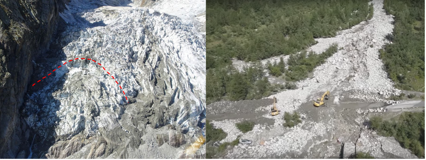
The Planpincieux Glacier (left side) with the terminal part at high risk of collapse. The landslide event of August 2018 (on the right side) which wiped out several cars and a couple lost their lives after their car was hit.